

Gokyo Valley Trek Map
- Places
- By accessnepaltour
Wanna see the heaven on Earth? The Gokyo Valley Trek will take you there. Located in the Everest region commonly known as the Khumbu region, it is the heart of the Himalayas. However, to visit this natural paradise, a well-planned Gokyo Valley Trek Map is essential.
The Gokyo Valley Trek route is considered one of the most beautiful trails in the Everest region. As you walk through dense rhododendron forests, surrounded by giant snow-capped mountains and breathtaking landscapes, it takes you closest to nature. The best part of this trek is when you get to see the turquoise glacial lakes and the gorgeous view from the top of Gokyo Ri 5,357 m/ 17,575 ft. The sunset and sunrise view from the top as it reflects a golden hue on the snow-capped mountains is another highlight of this trek
Related Packages
Gokyo Lake Trek - 13 Days
 5,357m/17,575ft
 Moderate
 All
Inclusive Plan
All
Inclusive Plan
Gokyo Valley Trek is a moderate-level trek. Therefore, a proper Gokyo Valley Trek Map is key for the successful completion of the trek. The Gokyo Trek map is a must-have item to understand the condition and way of trails, elevations, or altitude, and to not miss any key landmarks during the trek. This trip is ideal for trekkers who are looking for an adventure that gives them a taste of Nepalese culture. During the trek and walk along the Dudh Koshi River, you will get to visit traditional Sherpa villages and monasteries with great history.
The route to Gokyo Valley briefly overlaps the route to one of the most popular destinations, Everest Base Camp. However, as you walk deeper into this region, the trails will be more peaceful and the crowd also fades away. For the nature enthusiast, Everest Gokyo Valley Trek is the ideal option. Just imagine, being surrounded by the 360-degree view of giants like Everest (8,849 meters/ 29,032 ft), Lhotse (8,516 meters/ 27,940 ft), Makalu (8,463 meters/ 27,824 ft), and Cho Oyo (8,188 meters/26,864 ft), as you walk on the serene paths.
Treat yourself to this amazing Gokyo trek as we will help you to make this dream come true with our detailed Gokyo Valley Trek map. Without missing any details about the altitude, popular tourist spots, route details, itinerary, difficulty level, and cost, we will share everything. Explore the beauty of Gokyo region one of Nepal’s best-kept trekking secrets!
Gokyo Valley Trek Map and Route:
For a smooth trip anywhere, a map is a crucial part of finding the route. Therefore, if you are planning a trip to Gokyo, having a Gokyo Valley Trek map is needed for a memorable and safe trek. It is known for being one of the most beautiful trekking routes and that is less crowded and connects the trekkers closely to nature. To reach this pretty destination, let’s look at the overview of the Gokyo Valley Trek Map and Route.
The trek to Gokyo starts with a flight from Kathmandu to Lukla (2,860 m). Yes, we are talking about that flight, known for being one of the most dangerous airports because of its unusual location. Isn’t it thrilling and perfect for adventure seekers? For those who prefer to skip this part, there is another route option, Everest Base Camp Trek by road.

Gokyo Valley Trek Map
Once you reach Lukla, the trek continues to Phakding (2,610m) along with the Dudh Koshi River. There will be an overnight stay in Phakding followed by the trek to Namche Bazaar (3,440m), the famous tourist spot. There will be a rest day in Namche for the acclimatization. You can explore around this bustling Sherpa village as an acclimatization which is crucial for preventing altitude sickness.
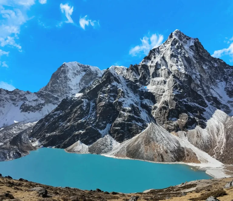
From Namche, the Gokyo Valley Trek Map splits the route from the Everest Base Camp trail. We will trek until reaching another Sherpa village Dole (4,200m). Starting from here, the route involves steep climbing and elevations will increase. Once you arrive at Machhermo (4,470m), a small village, you be overwhelmed by the beauty of the surrounding mountains. The landscapes start changing as you continue the trek until reaching Gokyo Lakes (4,790m). The view is really a sight for the eyes as you see the dotted turquoise lakes, surrounded by snow-capped mountains, and icy ground. It’s a snow paradise and feels magical looking at those breathtaking views.
After enjoying the beauty of those glacial lakes, our next destination is the ascent to Gokyo Ri (5,357m). It is the highlight of the trek as you reach the summit, the mesmerizing panoramic view of four of the world’s highest peaks: Everest, Lhotse, Makalu, and Cho Oyu. Aligning with your itinerary you can hike up there because both sunrise and sunset views are worth it. You can also get to see the view of the Ngozumpa Glacier, the longest glacier in the Himalayas.
If you are seeking more thrill and adventure, you can add some additional side trips like crossing the Cho La Pass (5,420 m) and visiting Everest Base Camp (5,264m). You can also explore the fifth and sixth Gokyo lake if you have extra time. Following this, the return journey starts as a trace back through Machhermo, Dole, Namche Bazaar, and Lukla for the flight back to Kathmandu.
Gokyo Lake Trek Difficulty:
Gokyo Lake Trek is a moderately difficult level trek. That is also the main reason for the need for a well-designed Gokyo Valley Trek Map. Though, it is challenging but it’s not like trekking to Gokyo Valley is completely impossible. If you are planning for a trek to Gokyo, all you need to do is choose the Gokyo Valley Trek package, book the spot, prepare yourself physically, and go through the Gokyo Valley Trek Map.
Some of the factors that make the Gokyo Lake Trek challenging are because of the high altitude, long trekking hours, and steep ascents. However, it is achievable if your beginner at the trekking field, unlike the Everest Three High Passes Trek which is very strenuous and difficult.
For the safe and smooth trek there are some things you need to prepare beforehand like good physical fitness and increased endurance level. Other factors like acclimatization are also extremely important. For more deeper understanding, we have a detailed breakdown of why the Gokyo Valley Trek is moderate:
1. High-Altitude and Sickness:
If you take a look at the Gokyo Valley Trek map, the maximum altitude trekkers have to go through is 5,357 meters (17,575 feet) at Gokyo Ri. Trekking in high-altitude regions is difficult due to the lack of oxygen. The more you ascend more the oxygen level drops leading to altitude sickness. Therefore, acclimatization is mandatory to prevent yourself from getting altitude sickness. Walk slowly, drink plenty of water, and give rest to your body properly.
- The journey starts from an altitude of 2,860 m from Lukla and gradually to 4,790m from Gokyo.
- Most of the itinerary and Gokyo Valley Trek map include Namche Bazaar (3,440m) as a resting point to adjust to the altitude.
- Keep checking your body and if you feel any of the symptoms like headaches, nausea, dizziness, and shortness of breath inform the guide.
- Don’t walk too fast, give time for your body to adjust to altitude.
2. Distance and Duration of Trek:
The total day to complete the Gokyo trek according to the Gokyo Valley Trek map is between 10 to 14 days. However, the duration to complete the trek totally depends on the trekkers, itinerary, physical strength, package, and acclimatization days. Every day trekkers have to walk for 5 to 7 hours on average. The typical distance to walk per day ranges between 8 to 15 km (5 to 9 miles).
- The Gokyo Valley Trek map route has many steep ascents, descents, rocky paths, and narrow ridges due to its remote and high location.
- The most challenging part of this trek is trekking between the Machhermo to Gokyo because of the steep and continuous climb.
- Another difficult part of the Gokyo Valley Trek Map is the Gokyo Ri summit as the route involves a steep, zigzag ascent of about 600 meters (1,970 feet).
3. Weather Conditions:
One of the major concerns during the trek in the Himalayan region is weather conditions. Gokyo Valley is located at a high altitude and during the winter it will be extremely cold and there will be loads of heavy snowfalls. This is also the reason for the need for the Gokyo Valley Trek map.
Mostly in the Winter season, the weather is unpredictable, especially in the Everest region. During the nighttime and morning, the temperature drops significantly. It is a difficult trek in winter because there will be a high chance of snowfall, extreme cold, blockage of trails, icy paths, and slippery routes.
- The best times to visit Gokyo Valley are in the Spring (March-May) and Autumn (September-November) seasons because it offers great visibility and pleasant temperatures.
- Winter (December-February) season is very harsh for climbing and trekking as the temperatures drop to -20°C (-4°F) or lower at night.
- Another season to avoid is the Monsoon season (June-August) because of the heavy rainfall which causes slippery routes, landslides, floods, poor visibility, and leaches.
- Warm clothes and high-quality trekking shoes and equipment suitable for trekking in cold areas are required.
4. Difficult Terrians and Routes:
The Gokyo Valley Trek map has diverse routes and trails. You have to trek through the routes like steep cliffs, rocky trails, suspension bridges, stone-paved paths, and glacier crossings. Therefore, it’s important to bring high-quality trekking gear and equipment. It is highly suggested to walk in a duo and always follow the instructions of the guide as they know the best. Read the Gokyo Valley Trek map carefully so as not to compromise on the adventure.
- A detailed Gokyo Valley Trek map is required when trekking to Gokyo Ri near the Ngozumpa Glacier (Nepal’s largest glacier) due to icy paths, giant rocks, and moraines.
- The trail between Dole and Machhermo is one of the most difficult and physically demanding parts.
- Because of the loose gravel, trekkers have to be extremely careful and cautious while coming down as there will be a risk of slipping.
Related Packages
Gokyo Lake Trek - 13 Days
- 5,357m/17,575ft
-
Moderate
- All
Inclusive Plan
5. Physical Fitness:
Trek to Gokyo Valley doesn’t require any trekking experience. It is a beginner-friendly trekking destination but there are some aspects you should prepare yourself before trekking to Gokyo Valley. Being physically fit and well-prepared is the key part of the smooth and safe trek to Gokyo.
- 4 to 6 weeks prior to your trek, start doing a Cardio exercise like running, cycling, swimming, or hiking to build stamina.
- For strength training do lower body exercises like leg workouts, squats, lunges, and core exercises which help in improving endurance for long trekking days.
- Prepare yourself mentally as walking for long hours and harsh conditions is both physically and mentally demanding.
6. Technical Skills:
The trek to Gokyo Valley doesn’t require any prior experience and trekking skills. But still, you should be familiar with walking on high cliffs. High-altitude region involves diverse terrains like steep ascenting and descending. Therefore, having a few technical skills and knowledge of walking at high altitude place are plus point.
- Research and study altitude sickness symptoms, prevention measures, and first aid tips for safety purposes.
- Trek with a government-licensed and expert guide for emergency support, and guidance, and look through the Gokyo Valley Trek map.
- Hire a porter to carry heavy loads, so that you can trek with easiness.

EBC Gokyo Trek Itinerary:
Day 01: Arrival Day in Kathmandu
Day 02: Fly to Lukla; Trek to Phakding
Day 03: Trek to Namche Bazaar
Day 04: Acclimatization Day at Namche Bazaar
Day 05: Trek to Tengboche
Day 06: Trek to Dingboche
Day 07: Acclimatization Day at Dingboche
Day 08: Trek to Lobuche
Day 09: Trek to Gorakshep and Everest Base Camp and back to Gorakshep
Day 10: Trek to Kala Patthar and Trek back to Pheriche
Day 11: Trek to Phortse
Day 12: Trek to Machhermo
Day 13: Trek to Gokyo
Day 14: Day exploration hike to Gokyo Ri and back to Gokyo
Day 15: Trek to Dole
Day 16: Trek to Namche Bazaar
Day 17: Trek to Lukla
Day 18: Fly to Kathmandu
Day 19: Departure from Kathmandu
Gokyo to Gokyo Ri Distance:
The distance between Gokyo (4,790m / 15,715ft) and Gokyo Ri (5,357m / 17,575ft) is about 1.5 to 2 kilometers (0.9 to 1.2 miles). Though the distance between them is short if you look at the Gokyo Valley Trek map, it is extremely challenging due to its high location. It includes lots of ascents and gravel routes. To climb Gokyo Ri from Gokyo takes around 2 to 3 hours to complete. Though the hike is short you will elevation gain of 570 meters (1,870-foot) suddenly. The increase in height means more difficulty.
However, it’s difficult to estimate the total time to complete the summit. Some of the factors like the trekker’s pace, fitness level, and acclimatization level affect the climbing hour. It is a physically demanding hike, trekkers have to walk on steep gradients and high altitudes make the climbing slow. Looking at the Gokyo Valley Trek map, the trek starts from the village. We will climb toward the base of Gokyo Ri after crossing the small stream.
From this route onward you have to prepare yourself physically and mentally as the climbing involves steep and rugged paths. You have to walk on the loose gravel and sharp rocks making it quite difficult the more you go up. Further, as you get closer the last push is needed because it is the steepest and most exhausting. Due to the lack of oxygen and the difficult route, climb slowly and carefully. There will be a high chance of getting altitude sickness around here. Therefore, we recommend you take a frequent break between the trek to balance the energy. Immediately inform your guide if you feel any symptoms like shortness of breath, dizziness, and fatigue.

Gokyo valley trek map
To get the best view of sunrise, you have to start the trek early in the morning. If you climb early, you will be able to enjoy the sunrise view closely, and there will also be more visibility around that time. All the hard work pays off once you reach the summit and see the panoramic views of Everest, Lhotse, Makalu, Cho Oyu, and the Ngozumpa Glacier.
Gokyo Valley Trek Cost:
The average Gokyo Valley Trek Cost typically starts from $1,560 US dollars. If you are looking for a package Access Nepal Tours and Trekking offers an all-inclusive Gokyo Valley Trek package just to make your dream come true. Everyone prefers to travel safely and hassle-free. Our package is designed for those who are busy planning a whole trip but still want a safe trip without missing any parts.
Access Nepal guarantees a safe trip along with a budget-friendly Gokyo Lake Trek cost. Throughout the trek and stay in Kathmandu, accommodation is arranged along with full board meals during the trek. The package includes airport transfer and round-trip flight tickets. To ensure your safety and comfort, we provide experienced government-licensed guides and porters. So, what is the delay if you are looking for a trip to Gokyo then give us this opportunity, we promise to give you the trip of your life.


Leave Your Comment
Awards and Achievements
Access Nepal Tour and Treks has been recognized with TripAdvisor’s prestigious Travelers’ Choice Award for multiple consecutive years, reflecting our unwavering commitment to quality and clients’ satisfaction.


COMMENT(1)
研究你的文章, 我明白, 生活更精彩。感谢 带来的感觉。