

Everest Base Camp Trek Map
- Places
- By accessnepaltour
The legendary trek to Everest Base Camp is one of the most iconic trekking destinations in the world. The Everest Base Camp Trek map follows various routes one can take to conquer this journey and witness the beauty of setting foot on the Base Camp of the world’s tallest mountain.
Every route in this adventurous trek takes you through some of the most beautiful views of the Khumbu region, where you can witness the diverse culture, landscapes, lush green forests, and several rare species of Flora and Fauna.
Understanding the detailed Everest Base Camp Trek map is vital for planning your route, managing various stops for acclimatization on high altitudes, and making the most of your journey.
The Everest Base Camp Trek map follows various routes, from the traditional flight to Lukla and trek to various popular stops such as Phakding, Namche Bazaar, and Tengboche, to taking on other less-crowded paths such as the Gokyo Valley. The trek provides unique experiences for every trekker to meet their personal preferences and their preferred path.
Like the popular saying, “It’s about the journey, not the destination”, the route you take and the map you follow to reach the Everest Base Camp are equally crucial in making your journey to the Everest Base Camp an unforgettable experience.
In this blog, we will cover all the necessary information regarding the detailed Everest Base Camp Trek map and the various routes travelers can take to complete this once-in-a-lifetime adventure. Whether you’re going solo or with a group, this guide breaks down the Everest Base Camp Trek Route map in detail, covering key villages, altitudes, route variation, as well as tips for navigation.
The Everest Base Camp Trek map not only acts as a guide but is an essential one must not miss out on to fully experience the beauty of the Himalayas.
Overview of the Standard EBC Trek Map
The Standard Everest Base Camp Trek is a 14-day journey in the Khumbu region that covers about 130 kilometers (81 miles) of total distance. The trek officially starts after you land in the famous Lukla Airport, also known as the Tenzing-Hillary Airport, and follows the Khumbu Valley to the Everest Base Camp.
Here is a brief breakdown of the map of the Everest Base Camp Trek:
1. Flight from Kathmandu to Lukla
Your journey to the Everest Base Camp begins with a flight to Lukla from Kathmandu. This thrilling flight takes about 30 to 40 minutes and lands on one of the most daring airstrips in the world at Lukla (2,860 m).
2. Lukla to Phakding
Trekking officially begins after you land at the famous town of Lukla. From there on, you will trek to Phakding (2,610m), covering an approximate 6-7 kilometers in distance.
3. Phakding to Namche Bazaar
Next, you will trek from Phakding to the popular acclimatization hub at Namche Bazaar. Sitting at an altitude of 3,440 meters, Namche Bazaar is also known as the “Gateway to Everest” and is a famous stop for trekkers in the Khumbu region. You will be spending an extra day here at Namche for acclimatization to the high altitude.

4. Namche Bazaar to Tengboche
Following Namche Bazaar, the Everest Base Camp Trek map follows trekking to the small settlement of Tengboche (3,867m). The trek to Tengboche covers an approximate distance of 10 kilometers.
5. Tengboche to Dingboche
The map of the trek to Everest Base Camp continues toward Dingboche. Dingboche (4,410m) is a small village and another popular spot for acclimatization before the final stretch to Everest Base Camp.
You will spend an extra day here at Dingboche for acclimatization.
6. Dingboche to Lobuche
The Everest Base Camp route continues to Lobuche (4,940m), covering an approximate distance of 8 kilometers. This is the last journey before heading on to the Everest Base Camp the next day.
7. Trek to Gorak Shep and EBC, then back to Gorak Shep
After Lobuche, the Everest Base Camp Trek map continues toward Gorak Shep and then to Everest Base Camp (5,364m). You will then return to Gorak Shep to end the day. The total distance you will be covering this day will be approximately 15 to 20 kilometers.
8. Kala Patthar to Pheriche
The route then takes you to the summit of Kala Patthar (5,550m), the highest point of the Everest Base Camp Trek. You will then descend to the village of Pheriche.

9. Pheriche to Namche Bazaar
Following the map of the Everest Base Camp Trek, you will continue on your return journey from the village of Pheriche to the town of Namche. You will be covering approximately 23 kilometers on this trek.
10. Namche to Lukla
You will be returning to Lukla, ending your trekking adventures, and preparing for the flight back to Kathmandu the next day.
11. Fly Back to Kathmandu
Finally, the Everest Base Camp Trek map concludes with a flight back to Kathmandu from Lukla.

Everest Base Camp Trek Route Map
Here is an altitude chart of the standard Everest Base Camp trek map:
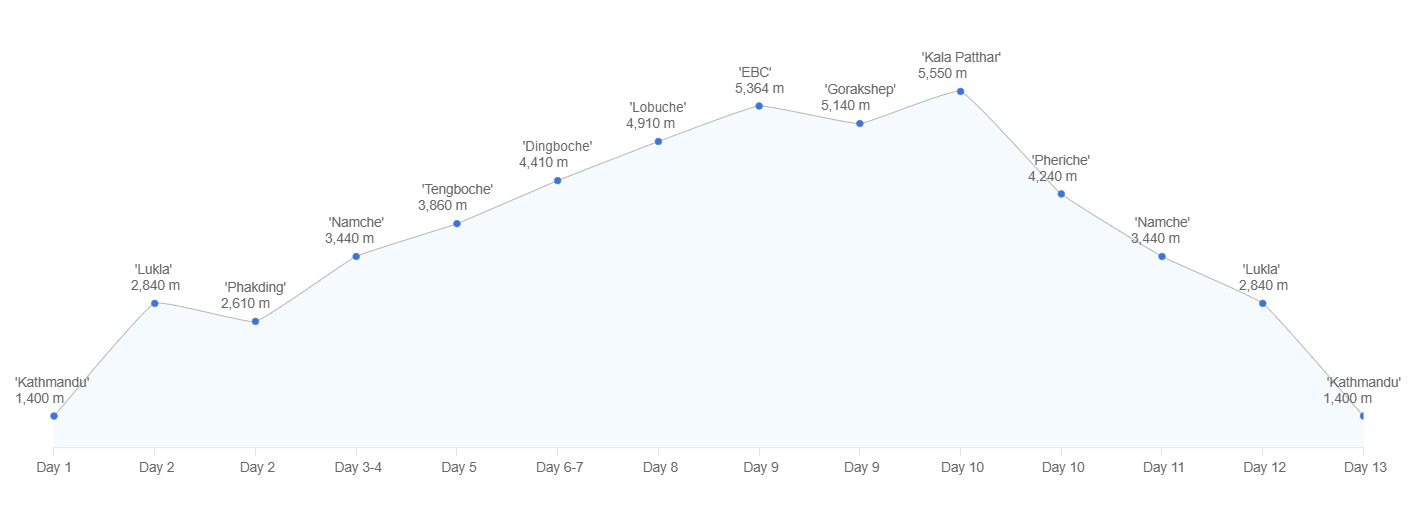
Everest Base Camp trek altitude chart
You can download our Everest Base Camp trek map PDF file from here: Everest_Base_Camp_Trek_Map.
Key Locations on Everest Base Camp Trek Map
On route to the Everest Base Camp, trekkers travel through several key locations that serve as crucial stops during their journey. These key locations hold special significance among the local people and trekkers passing by in the Everest region.
Either serving as an acclimatization stop, a major viewpoint to witness the beauty of the Khumbu region, or hosting as a place of major cultural significance, these key locations are a must-visit on the trek to the Everest Base Camp.
- Lukla: The famous town of Lukla is one of the first and major locations on the Everest Base Camp Trek map. You will board a direct flight from Kathmandu to Lukla and begin your trekking journey. Lukla is famous for its one of the world’s most dangerous airports and is also known as Tenzing-Hillary airport. The famous town of Lukla is basically your entry point into the Khumbu region.
- Namche Bazaar: Namche Bazaar is another popular stop on the Everest Base Camp Trek map. This famous town is a popular acclimatization spot among trekkers in the Everest region. People often spend an extra day here to adjust to the high altitude and do any last-minute shopping before they head on their treks. The town of Namche is also referred to as the “Gateway to Everest”. When in Namche, you can visit the famous Everest View Hotel during an acclimatization hike, which is the highest altitude hotel in the world.
- Tengboche: Tengboche is a small settlement you stop at right after Namche Bazaar. This small settlement acts as one of the key locations on the Everest Base Camp Trek map and is famous for the Tengboche Monastery. The Tengboche Monastery is one of the most significant monasteries in Nepal and acts as a spiritual center of the Khumbu region. From the small settlement of Tengboche, you get to enjoy some of the best views of various mountain ranges, including Mount Everest, Lhotse, Nuptse, Thamserku, and Ama Dablam.
- Dingboche: The village of Dingboche serves as another major acclimatization stop for the trekkers. Dingboche is your second acclimatization stop before your final stretch to the Everest Base Camp.
- Kala Patthar: Kala Patthar is one of the major highlights on the Everest Base Camp Trek. Situated at an altitude of 5,550 meters, Kala Patthar is the highest point of the Everest base Camp Trek and offers the best close-up views of some of the world’s tallest mountains, Mount Everest, Lhotse, Nuptse, and Ama Dablam, as well as the Khumbu Glacier and Icefall.
Which Route is Best for Everest Base Camp?
There are several routes for trekkers to choose from on the Everest Base Camp Trek map. While the standard route is the most popular, the map includes several alternatives, each leading to its own unique travel experiences.
Here are some of the alternative trekking routes on the Everest Base Camp Trek map for trekkers to choose from to embark on this magical journey.
Alternative Trekking Routes on the Everest Base Camp Trek Map
Everest Base Camp and Gokyo Lakes Trek Map via Cho La Pass
The Everest Base Camp and Gokyo Lakes Trek map takes you on a unique journey that is different from the standard EBC route. If you’re someone who prefers trekking on a quiet trail with fewer crowds, the Gokyo Lakes via Cho La Pass can be the best route for you.
The Everest Base Camp and Gokyo Lakes Trek map follows a peaceful and serene trail separate from the traditional Everest Base Camp Trek map. The route after reaching the famous Namche Bazaar follows a trek to the village of Dole and not to Tengboche. Passing by Macchermo, you then reach the magical Gokyo Valley and witness its serene lakes.
After your stay at the Gokyo Valley, the trek continues toward the daring Cho La Pass (5,420m). You will trek to Lobuche after crossing the high mountain pass and then finally reconnecting with the traditional EBC route.

Everest Base Camp and Gokyo Lakes Trek Map via Cho La Pass
Everest Three Passes Route
The Everest Three Passes route is a unique journey, unlike the traditional Everest Base Camp Trek map. On the Everest Three Passes trek route, you will be able to experience the beauty of Everest from every possible angle.
The Everest Three Passes Trek is an adventure crafted for trekkers looking for something more challenging and adventurous than the standard Everest Base Camp Trek. You will be crossing three high-altitude mountain passes in this trek route, making for a brilliant adventure in the Himalayas.
The Everest Three Passes route follows trekking to Chukhung after your acclimatization day at Dingboche. Then, you continue on to the classic route to reach Lobuche via Kongma La Pass (5,535m). After conquering the Everest Base Camp, you head on your return trek to Dzongla, followed by a trek to Thangnak, crossing through the daring Cho La Pass (5,420m). The Everest Base Camp Trek map then follows the route toward the serene Gokyo Valley.
Finally, from the magical Gokyo Valley, you trek to Marlung via the Renjo La Pass (5,360m).
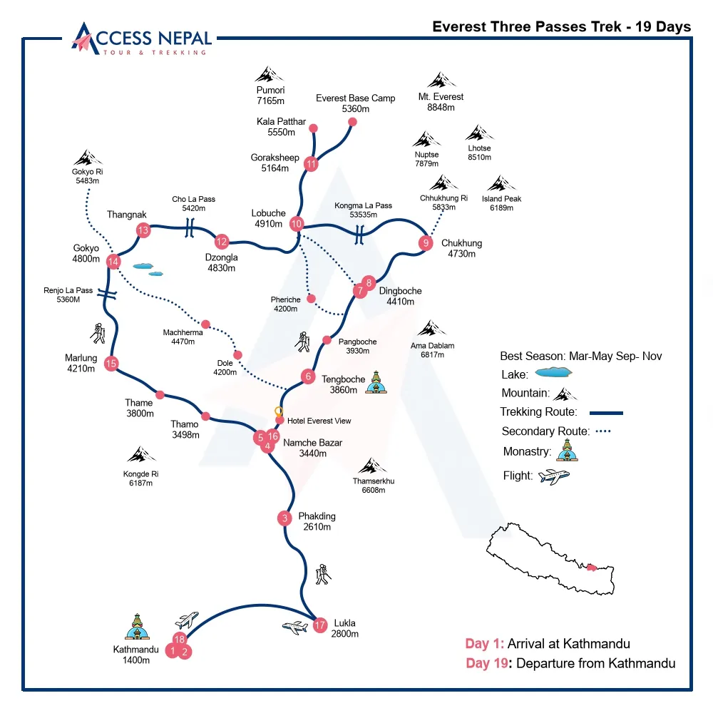
Everest Three Passes Trek Route Map
Jiri to EBC Trek Map
The Jiri to Everest Base Camp Trek Map is a historically significant trail and is even referred to as the “Hillary Trail“, as it was the original path taken by Sir Edmund Hillary and Tenzing Norgay during their expedition in 1953.
This classic route starts with a drive from Kathmandu to Jiri and marks the beginning of your trekking journey from Jiri to Bhandar. After Bhandar, you will trek to Sete and then climb up to Lamjura La Pass (3,530m) before descending to reach the Sherpa village of Junbesi. The trek then continues to Nunthala before finally reconnecting with the traditional EBC route.
The Jiri to Everest Base Camp Trek Map is an excellent alternative for those with extra time on their hands who want to acclimate gradually. The trail also offers a more peaceful experience and is less crowded than the standard Everest Base Camp route. 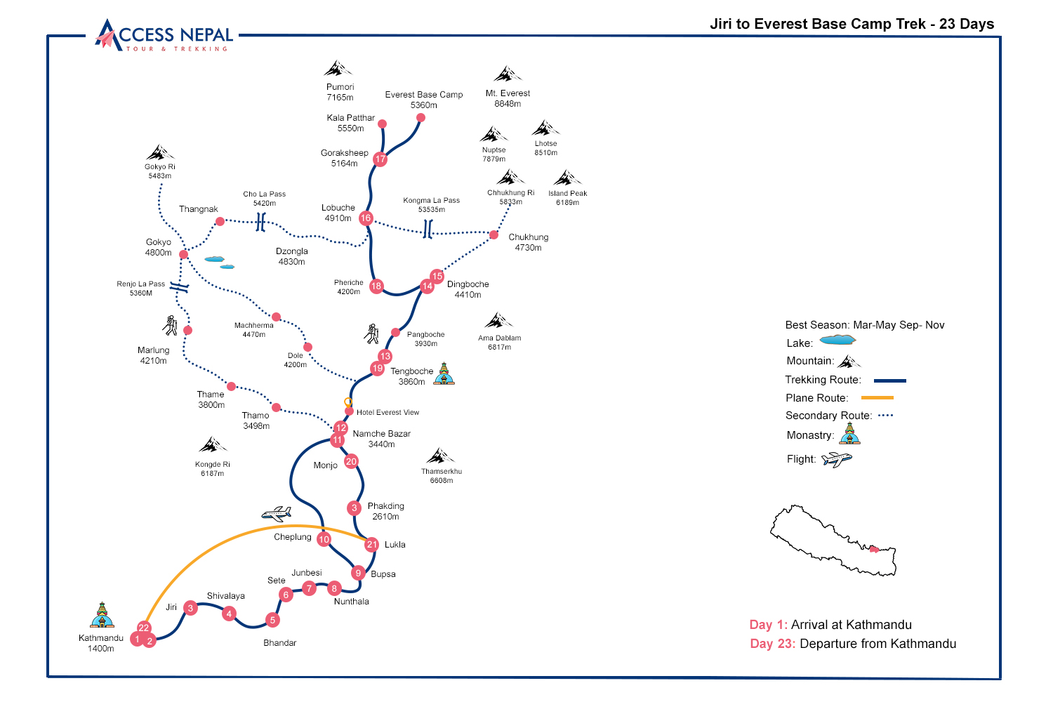
Jiri to Everest Base Camp Trek Map
Visual Insight of the Path to Everest Base Camp Trek


Awards and Achievements
Access Nepal Tour and Treks has been recognized with TripAdvisor’s prestigious Travelers’ Choice Award for multiple consecutive years, reflecting our unwavering commitment to quality and clients’ satisfaction.


Leave Your Comment