
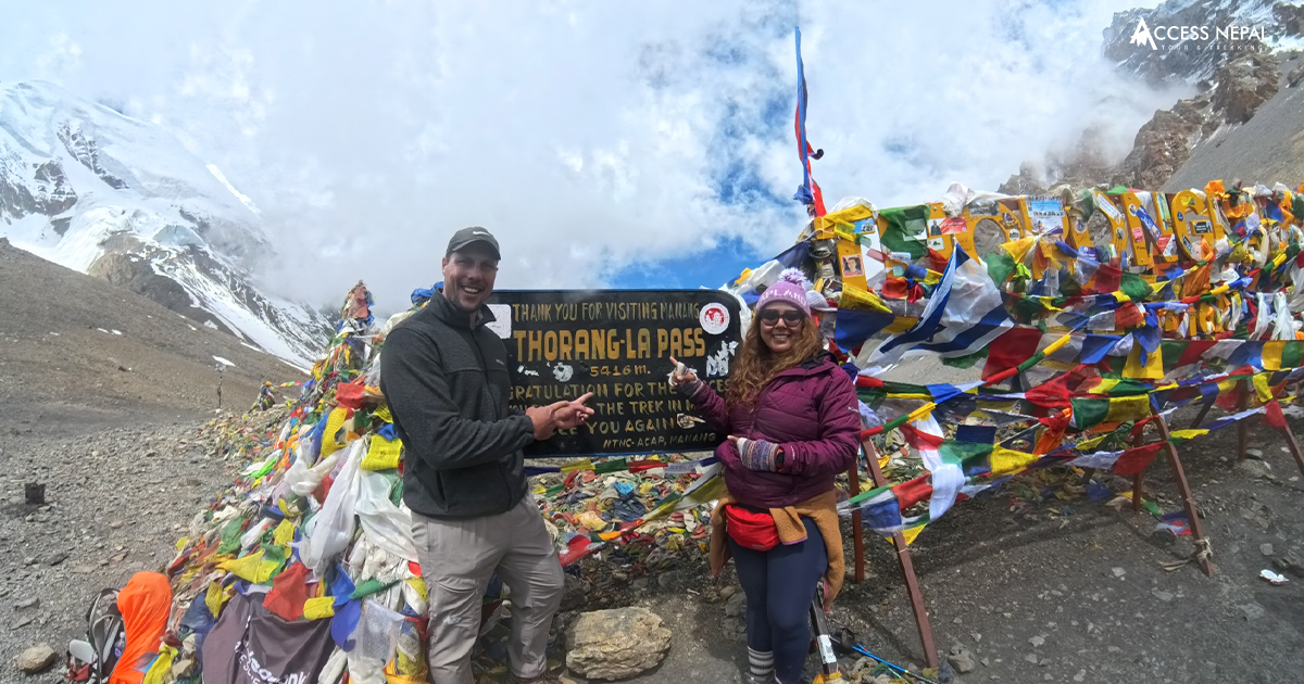
Thorong La Pass
- Places
- By Sanchita Pokharel
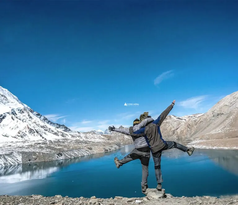
Thorong La Pass is a place that heightens the adrenaline of every trekker. This high mountain pass is one of the climax parts of the classic Annapurna Circuit Trek. Standing at a height of 5,416 meters (17,769 ft) above sea level, it is the highest point on the Annapurna Circuit. Thorong La Pass is located between the Manang and Mustang districts. The beautiful Manang Valley surrounds it to the east, with the arid Mustang region to the west.
This blog offers a comprehensive guide that covers everything about Thorong La Pass, including its elevation and height, altitude and difficulty, weather and temperature, itinerary and costs, as well as important safety considerations (with historical data on trekking accidents). By the end, you’ll know what to expect when planning and crossing Thorong La Pass on the Annapurna Circuit.
Related Packages
Annapurna Circuit Trek - 16 Days
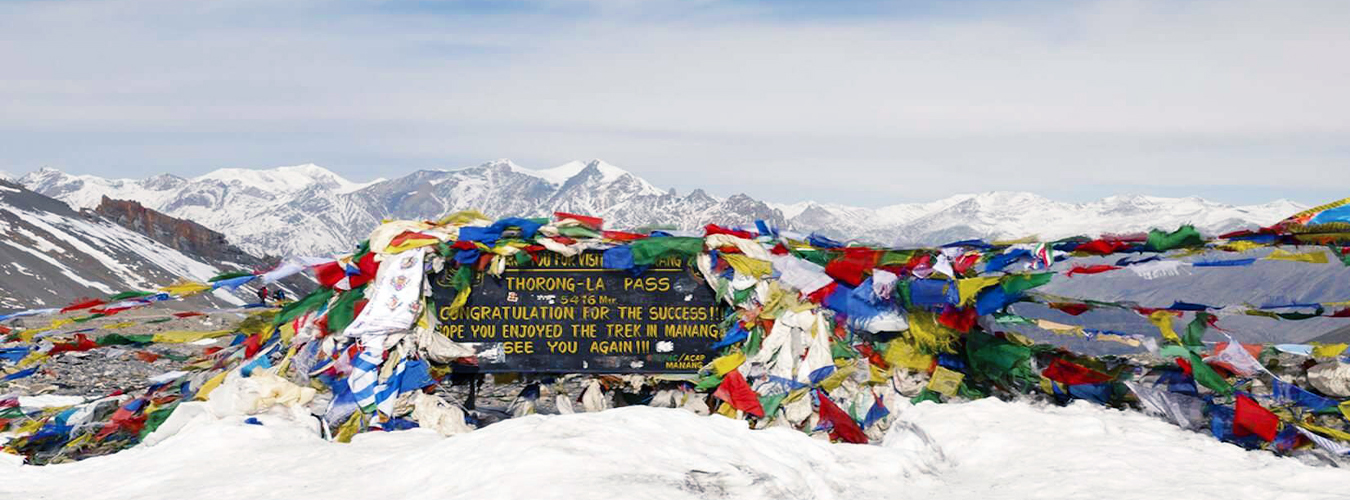
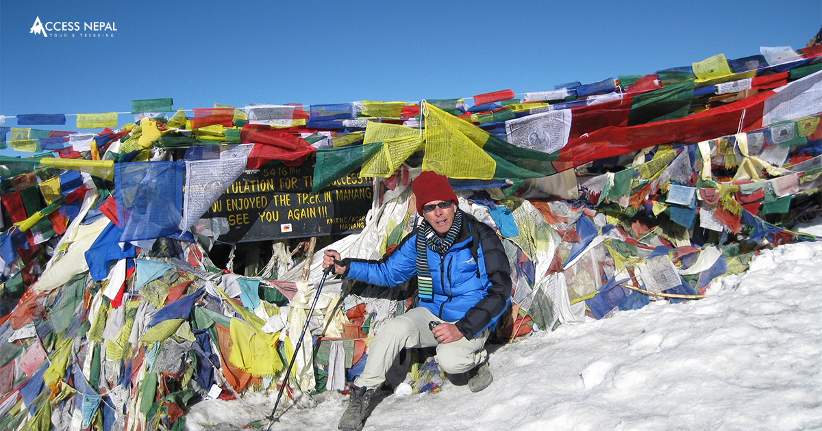
 5,416m/17,769ft
 Challenging
 All
Inclusive Plan
All
Inclusive Plan
Thorong La Pass Elevation
Thorong La Pass is 5,416 meters (17,769 feet) above sea level. This extreme altitude makes it one of the highest trekking passes in the world. The pass lies in central Nepal’s Damodar Himalaya range (north of the Annapurna Massif). In practice, trekkers usually cross Thorong La from the village of Manang (3,540 m) on the east side to Muktinath (3,762 m) on the west. The pass itself is marked by Buddhist chorten (stupas) and prayer flags at the summit.
Because Thorong La is the highest point of the Annapurna Circuit (AC), reaching it involves significant altitude gain. For most itineraries, trekkers ascend from about 4,000-4,600 m (from Yak Kharka or Thorong Phedi) up to 5,416 m on the crossing day. The long approaches and high camps make this climb safer by breaking it into stages.
In short, Thorong La’s elevation is extreme: it is roughly double the elevation of Mount Kosciuszko in Australia, and nearly 2,000 m higher than Mount Blanc in Europe. The pass touches the Tibetan Plateau’s fringe and has only half the oxygen of sea level at its summit.
This elevation means special preparation is needed; you’ll need warm gear and careful acclimatization to handle the thin air and cold environment.
What is the Height of Thorong La Pass?
In everyday language, people also refer to the height of Thorong La Pass, Nepal, meaning essentially its altitude. To be precise, Thorong La is 5,416 m (17,769 ft) high. You can think of this as approximately 5.4 kilometers straight up, or about 17,770 feet. By comparison, Everest Base Camp Trek is around 5,364 m, so Thorong La is even higher than that famous mountaineering camp. Because of this height, Thorong La often remains snow-covered and frozen even in peak trekking season.
The vast height of Thorong La also contributes to its dramatic scenery. From the summit, you see panoramic views: to the north lie the high peaks of the Damodar Himalaya (including Thorong Ri at 6,144 m), to the south, you look back over the Annapurna Massif, and to the west, the dry Mustang landscape unfolds.
The pass effectively marks the watershed of two river systems: meltwater on the east side drains into the Marshyangdi River, while on the west it flows into the Kali Gandaki. In practical terms, this height means the hiking is strenuous and the environment is very alpine. Most trekkers start the final push to Thorong La before dawn to avoid afternoon winds and cold; reaching the chortens and prayer flags at the summit (5416 m) is the reward after a steep climb.
Because the Thorong La Pass elevation is so high, even the day-to-day climate is extreme (see below). In clear weather, the sun is intense (so you need strong sun protection), but without the sun, it is bitterly cold. At 5,416 m, your body uses oxygen slowly, your feet feel heavy, and the risk of altitude effects (headache, nausea, breathlessness) is very real. All of this is tied to the pass’s height. Therefore, looking through Annapurna Circuit Map is essential.
Thorong la pass
Thorong La Pass Altitude
The altitude of Thorong La Pass, at 5,416 m, is one of its defining challenges. At this altitude, there is roughly 50% as much oxygen in each breath as at sea level. In other words, every step in the air can feel like a marathon step at home.
Trekkers on Annapurna Circuit often note that climbing beyond 4,000 m is tough, and at Thorong La the effort multiplies. In practical terms, this means your pace will be very slow, you will need frequent rest stops, and even minor exertion causes shortness of breath.
Because of these effects, acclimatization is critical on the Annapurna Circuit Thorong La Pass trek. Trekking organizations and rescue groups strongly recommend taking extra days at intermediate altitudes. For example, adding acclimatization or rest stops in the Manang Valley (at 3,500 m) before attempting the pass.
The rest stop gives your body a chance to adjust by producing more red blood cells and easing the impact of low oxygen. It’s common practice to hike to an alpine lake or side peak in Manang on acclimatization days, to gradually expose the body to higher altitude under controlled conditions.
Even with acclimatization, some symptoms are possible. Mild acute mountain sickness (AMS), headache, nausea, and fatigue can occur in many trekkers. There are occasional reports of serious AMS or high-altitude pulmonary edema (HAPE) in new trekkers who ascend too quickly.
Because of this, most guides treat Thorong La as a non-technical but physically demanding hike.
No special mountaineering equipment is needed to cross Thorong La Pass; it’s just a very steep hike. Thorong La is far from impossible. … The secret is allowing enough time for your body to acclimate to the altitude.
In short, the altitude of Thorong La (5416 m) means that oxygen is scarce and every step is effortful. Any trekker planning to cross it must respect the altitude: ascend slowly, stay hydrated, and watch for AMS symptoms. Following established trekking itineraries that include rest days (as outlined below) is one way to manage the pass’s great altitude safely. Otherwise, you can do the Short Annapurna Circuit Trek.
Related Packages
How Difficult is Thorong La Pass?
Thorong La Pass is challenging but doable for well-prepared trekkers. It is often described as one of the toughest sections of the Annapurna Circuit, but it is not a technical climb; you won’t need ropes or crampons in normal conditions, just stamina, endurance, and caution. The difficulty arises from the high altitude, the steep ascent on crossing day, and potentially harsh weather.
The final ascent to Thorong La involves climbing roughly 900-1,100 meters in one day from the high camp. For safety, Access Nepal Tours and Trekking’s Thorong La Pass itinerary includes an overnight at Thorong High Camp (4,600 m) and then rising to 5,416 m at the summit. That’s a near-vertical gain of about 800 m in a single day.
The path to pass is well-trodden (marked by prayer flags and chortens), but it is very steep and stony. When covered in snow or ice (in winter or during storms), it becomes slippery and dangerous. Thorong La Pass is not for the faint of heart. It presents a challenging adventure that requires physical and mental preparation. Steep switchbacks and thinning air make every meter of ascent progressively harder.
Elevation aside, strong winds often batter the pass by afternoon. Experienced guides always start before sunrise on crossing day, to reach the summit and descend before the afternoon winds pick up. If caught late, trekkers may face freezing gusts that can blow hard across the ridge. Visibility can also vanish in fog or blowing snow.
For these reasons, the standard advice is to leave camp around 4-5 AM to avoid afternoon storms.
It’s worth noting that the direction of travel affects difficulty. Almost all trekkers hike counterclockwise (Manang to Muktinath) because it spreads the altitude gain over more days and ends at higher elevations by gradual descent. The reverse (ascending from the Mustang side) is strongly discouraged: you would have to climb from about 3,670 m all the way to 5,416 m in a single stretch, which is much harder.
The west-to-east travel “does not allow sufficient time for acclimatization” and requires climbing over 1,200 m in one day. By contrast, going east-to-west allows a stepwise approach (e.g., Yak Kharka ➔ Thorong Phedi ➔ High Camp ➔ Pass) which, while still strenuous, is far safer for the body. Therefore, the Annapurna Circuit Trek with Tilicho Lake fits perfectly both safety and adventure-wise.
Related Packages
Annapurna Circuit Trek with Tilicho Lake - 18 Days
- 5,416m/17,769ft
-
Challenging
- All
Inclusive Plan
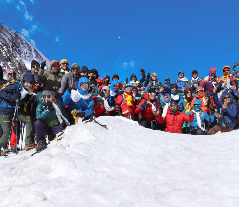
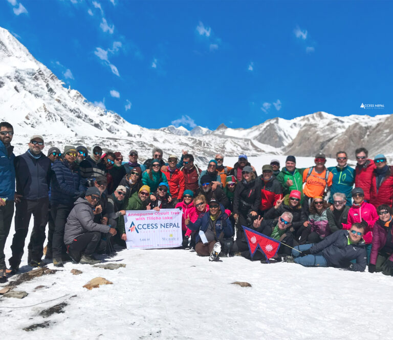
On a standard trek, most people find Thorong La Pass to be near the top end of their fitness level. If you are very fit and have time to acclimatize, the challenge is surmountable. Many trekkers of varying ages and nationalities make the crossing every year. However, without adequate preparation, it will feel extremely hard.
The key to climbing successfully is steady pacing, frequent rests, and listening to your body. On average, trekkers have to walk for 6-8 hours of hard hiking from the high camp over the pass to Muktinath. Therefore, we highly suggest you train for 1 or 2 months in advance (stair climbs, long hikes with weight, cardio training).
Despite its difficulty, reaching Thorong La is immensely rewarding. Many trekkers describe the final summit as one of the most thrilling moments of the Annapurna Circuit. You will experience altitude soreness and challenge, but no hazardous crevasses or knife-edge ridges.
In summary, Thorong La Pass is a strenuous high-altitude hike. It demands good fitness, careful acclimatization, and respect for the weather, but it does not require mountaineering skills. With the right preparation and (if possible) an experienced guide, it is within reach of most serious trekkers.
Thorong La Pass Weather
Annapurna Circuit weather or Thorong La Pass weather experiences extreme cold that changes dramatically with the season. It lies in the Himalayas’ rain-shadow region, so overall precipitation is limited by the Annapurna range. However, this does not mean the weather is mild; on the contrary, the high pass sees four distinct seasons:
Spring (March-May):
Spring is generally clear and dry on the Annapurna Circuit, making it one of the best times to trek. Days are mostly sunny with moderate temperatures at lower altitudes. As you climb above 3,000 m, days become cool and nights still drop well below zero.
At Thorong La Pass itself, the remaining snow from winter can still linger on the trail in March, but conditions rapidly improve in April-May. (By May, the rhododendrons bloom in the valleys). Importantly, spring is pre-monsoon, so heavy rain or snow is uncommon. The main weather risk in spring is occasional late snowfall or fog, but overall, the sky is clear.
Autumn (September-November):
Autumn is the peak trekking season. Monsoon has ended, leaving crisp, clear skies and excellent visibility. Daytime air is still warm in the lower valleys (10-20°C), but above 4,000 m it is cold. The weather is stable, which means ideally dry trails with minimal snow.
According to Himalayan guides, September and October provide the “best chance” for clear mountain views. Temperatures at Thorong La in autumn are cold (see next section) but manageable with gear. Autumn is considered the safest time to attempt Thorong La.
Summer/Monsoon (June-August):
This is the wet season. Despite Annapurna’s rain shadow, the Circuit receives significant monsoon moisture. Villages like Chame see daily showers, and higher passes accumulate new snow and slush. Thorong La itself can get very snowy or rainy.
In fact, rainfall in the Thorong La area can block the trail with snow at any altitude. It also brings a high avalanche danger; the ground is saturated, and weak layers form in the snowpack. For these reasons, virtually all trekkers avoid Thorong La during the monsoon. The heavy rains also make landslides and trail erosion more likely.
In short, June-Aug is unsafe for Thorong La crossings.
Thorong La Pass in winter
Winter (December-February):
Winter is extremely cold and snowy. The Annapurna Circuit towns become nearly deserted except for hardy winter trekkers. Thorong La remains technically passable in December, but conditions rapidly worsen. The Himalayan Rescue Association notes that from December to February, the pass typically accumulates 1-3 inches of snow.
Temperatures fluctuate from slightly below freezing in the day to deeply sub-zero at night. Winter storms can blanket the entire circuit in snow and cause blizzard conditions. Most porters, guides, and trekkers avoid crossing Thorong La in January and February due to the risk of avalanches and frostbite.
Aside from seasonal patterns, Thorong La’s weather also varies by geography. The Manang side (east) is more vegetated and slightly wetter, protected from the monsoon by Annapurna (as wheat fields and barley crops are possible there).
In contrast, the Mustang side (west) is very dry and barren, almost a cold desert, because virtually no monsoon moisture penetrates past the Thorong pass. This means the west side can be windy and have very low humidity. It also means that, once the weather is stable, the sky above Thorong La is often crystal clear.
In summary, Thorong La demands careful timing. The best time to visit Thorong La Pass is spring (March-May) and autumn (September-November). During these windows, the risk of snow-blocked trails or storms is lowest. One must avoid the monsoon and deep winter. Also, always carry proper cold-weather gear even in the “good season,” weather in the Himalaya can change rapidly.
Packing extra layers, a warm sleeping bag, and rain/snow gear is essential because storms above 5,000 m are life-threatening. Watching local forecasts and heeding guide advice can make the difference between an incredible trek and a dangerous situation.
Thorong La Pass Temperature
Because Thorong La Pass sits above 5,400 m, temperatures there are freezing year-round except for brief mild spells. Even in the warmest season, the pass itself is well below 0°C much of the day. To give some figures:
- In autumn (September-October), average daytime temperatures on the pass are around -4°C (about 25°F). Even when the low valleys are warm, Thorong La stays frigid. Nights plunge lower: by November, it’s normal to see below 5°C (23°F) around the pass. One trekking guide notes that in late autumn, “areas around the Thorong La Pass can go below -5°C.
- In spring (March-May), the situation is similar to autumn. March is still very cold; by April and May, daytime might reach -2 to 0°C at the pass (or a few degrees above if the sun is out), but nights remain well below freezing (-10°C or colder). Snow from winter may linger into March, but it usually melts by April at lower camps. By May, the sun is stronger, and the pass might only have patches of snow.
- In winter (December-February), Thorong La sees the most severe cold. According to Himalayan weather reports, daytime maxima on the pass typically remain between -3°C and 7°C. Night temperatures plunge far below that, not recorded exactly here, but other sources note that above 5,000 m at night can drop to -15°C or colder. A travel site notes that in January, high-altitude areas typically experience temperatures ranging from 1°C to -14°C on average. In any case, expect well below -10°C at night, and the wind chill can make it feel like -20°C or colder.
During the short monsoon season, any warm rain or snow will quickly freeze in the thin air, so temperatures are effectively at or below freezing anytime clouds cover the sun. So while daytime might rise a few degrees if the sun shines, it is safest to assume sub-zero temperatures above 5,000 m at any time from October through March.
In plain terms: plan for intense cold. Even warm-weather trekkers need heavy down jackets, gloves, balaclavas, and insulated boots for Thorong La. It’s recommended to bring layers for daytime (fleece, softshell + windbreaker) and then full winter gear (puffy down jacket, insulated pants, warm hat, gloves) for dawn-to-morning and for any snow.
Hand/foot warmers and high-SPF sunscreen are also prudent. Nights at camp (4,600-4,800 m) are extremely cold as well.
Finally, weather pattern at the pass often brings sudden cold snaps: trekkers have experienced hail, sleet, or blizzard conditions even in “good” season if an early storm blows in. So, packing for a severe cold and anticipating rapidly dropping temperatures is crucial.
Thorong la pass
Thorong La Pass Nepal Trekking Tips and Essentials
(Although not a separate heading requirement, it’s worth noting a few key tips to ensure a successful Thorong La trek.) Trek with reliable gear, sturdy hiking boots, warm layered clothing, rain gear, and sun protection. Pack high-calorie snacks for the summit day (sugary energy bars, chocolate). Drink lots of fluids and consider water purification tablets.
Importantly, walk slowly on the ascent and don’t push too hard: the thin air punishes overexertion. Carry a first-aid kit (with altitude sickness medication like acetazolamide or dexamethasone, if prescribed). Many trekkers bring microspikes or a walking pole for extra stability near the snow.
Finally, make sure you have travel insurance that covers high-altitude trekking and emergency evacuation. Helicopter rescues are possible in case of serious illness. If you trek with Access Nepal Tours and Trekking, we will take care of everything from arranging a helicopter evacuation to providing a first-aid box and medical help.
With thorough preparation and respect for the mountains, Thorong La Pass can be crossed safely. We have operated thousands of trekkers, leading guaranteed successful trips. Readiness and caution are the keys.
Thorong La Pass Trek Cost
Planning the budget for a Thorong La Pass trek involves several factors: permits, logistics, and daily expenses. For the Annapurna Circuit trek cost, independent trekkers typically need to pay for:
- Permits: Nepal requires an Annapurna Conservation Area Permit (ACAP) and a Trekkers’ Information Management System (TIMS) card. ACAP currently costs about NPR 3,000 (approx. USD $25) for foreign visitors, and TIMS about NPR 2,000 (USD $17). These must be obtained in Kathmandu or Pokhara before starting.
- Transportation: Bus or jeep fare from Kathmandu to the trek start can be around $5-$15. Many trekkers pay extra for a jeep from Besisahar to the trailhead, which could be $30-$50 per vehicle. At the end, a short flight from Jomsom to Pokhara is $100.
- Food and Lodging: On the trail, teahouse rooms cost roughly $3-5 per night (shared twin room), and meals (dal-bhat, noodles, soup) cost about $5-$10 per meal at higher altitudes. Expect to spend $20-30 per day per person for food and lodging in the high parts of the trek. Hot showers and battery charges each cost extra ($2-3 apiece).
- Guides and Porters: A trekking guide in Nepal costs about $25-$30 per day (all-inclusive), and a porter around $15-$20 per day (sharing weight with another porter). Hiring local support is optional but highly recommended for safety and convenience.
- Miscellaneous: Flights, visas, equipment rental, tips, and other personal expenses.
Access Nepal Tours and Trekking offers all-inclusive packages covering all the mentioned things at only $1,490 per person. Book our Annapurna Circuit Trek with Thorong La Pass as the peak trekking season is around the corner.
Thorong La Pass Deaths
Though adventure and trekking are fun, they also come with some drawbacks. Thorong La Pass has a sobering history of accidents and even fatalities. While many trekkers cross safely, the extreme altitude and unpredictable weather mean that serious incidents have occurred.
For data and risk factors, one of the worst disasters happened in October 2014, when a sudden cyclone-induced blizzard struck the Annapurna region.
In that event, reported deaths on the Annapurna Circuit reached around 40-43 people. Several media reports note that this was “one of the biggest trekking tragedies to hit Nepal”. In particular, avalanches in and around Thorong La Pass were responsible for many casualties.
In one report, at least 16 people were killed by an avalanche right at the pass itself. Another separate accident on the descent from Thorong La killed an additional four trekkers.
These 2014 figures are unusually high, but they highlight the potential danger. To date, there have been many smaller incidents: trekkers trapped by snowstorms, cases of severe altitude sickness, and even a few fatalities from exposure. It’s estimated that in a given decade, a handful of trekkers may die on the entire Annapurna Circuit (often in the Thorong La or Dhaulagiri areas) due to avalanches or altitude problems.
For example, medical and press reports list dozens of injuries and dozens rescued in major storms, along with the 40+ fatalities. Even outside of disasters, trekkers occasionally collapse from cardiac or AMS-related events.
Risk Factors:
The main hazards at Thorong La Pass are avalanches, severe weather, and altitude. The pass sits at the meeting point of mountain ridges, so it can receive heavy snow (even 1-3 inches in a single storm) and very cold winds. Whiteouts can disorient hikers. A treacherous night stranded on the pass can be life-threatening.
Additionally, the pass is remote: if someone does fall ill, help can be far away. Trail crews and guides can radio for helicopter evacuations, but in bad weather, choppers cannot fly. The combination of high altitude (risk of HAPE/HACE) and avalanche risk makes this crossing non-trivial.
Given these risks and historical data, trekking to Thorong La Pass is not a casual undertaking. We strongly advise trekking only with experienced support. Using a professional trekking company greatly reduces danger.
Expert guides know how to read weather forecasts (to avoid storm windows), recognize altitude sickness signs, carry emergency oxygen, and navigate around avalanche-prone slopes.
For example, companies like Access Nepal Tours and Trekking emphasize safety by providing seasoned Sherpa guides, proper acclimatization schedules, and radio/heli evacuation plans if needed. Going with such a company adds expense, but it can save lives.
Remember: even world-class trekkers and mountaineers have been victims of Himalayan weather. The 2014 disaster itself claimed the lives of trekkers from many different nationalities, underscoring that no one is invincible.
Thorong La Pass carries real risk. Planners should factor in this risk fully and not attempt the trek alone or without guidance. The best precaution is conservative: trek in good seasons only, watch for weather alerts, and have professional support. By doing so, most trekkers enjoy Thorong La Pass safely every year.
Thorong La Pass is a legendary and demanding highlight of Nepal trekking. Its elevation (5,416 m) and role in the Annapurna Circuit mean that any trekker who tackles it will have planned carefully for altitude, cold weather, and difficulty.
The rewards are spectacular: a sense of achievement at the summit, incredible mountain vistas, Himalayan culture, and the enjoyment of the major attractions of the Annapurna Circuit Trek. However, the stakes are real; severe cold and unpredictable storms can pose danger.
Throughout this guide, we have covered elevation, height, altitude effects, difficulty, weather, temperature, itinerary, and even fatality data. We see that Thorong La Pass is not a casual hike. Trekking companies like Access Nepal Tours and Trekking emphasize expertise: they take care of acclimatization scheduling, route choices, emergency planning, and the hard part of carrying gear.
This expertise is precisely why using a professional company is highly recommended, especially in such a risky environment. Guides know how to trek in snow, when to hold back due to weather, and how to respond to altitude sickness.
For you, the adventurer, the takeaway is: prepare thoroughly. Train physically, acquire good gear, and plan enough days (including several at Manang for acclimatization). Book permits in advance, and consider a guided package (the peace of mind can be worth the cost).
Check the weather and learn about the symptoms of altitude sickness. If you follow these precautions, crossing Thorong La Pass becomes a remarkable triumph rather than an ordeal.
In the end, the Thorong La Pass trek is one of the most iconic journeys on the Annapurna Circuit. It challenges you with extreme altitude and conditions, but rewards you with one of the most unforgettable mountain experiences on Earth. With the right respect for the mountain and solid preparation, you will join the ranks of those who safely walk the crown of the Himalaya.
FAQS (Frequently Asked Questions)
How high is Thorong La Pass?
Thorong La Pass, situated in the Annapurna Circuit, stands at an elevation of 5,416 meters (17,769 feet) above sea level. Thorong La Pass is one of the highest trekking passes in the world.
How hard is Thorong La Pass?
Thorong La Pass is quite challenging, mainly due to the high altitude and steep ascents. A moderate level of trekking experience and good endurance are required to conquer the trek successfully.
Where is Thorong La Pass?
Thorong La Pass is a high mountain pass on the Annapurna Circuit in Nepal. It falls in the Manang district and connects Manang Valley on the north side, as well as Muktinath/Marpha on the south side.
How long is Thorong La Pass?
Thorong La Pass is generally not that long; all it takes is 7 to 10 hours of trekking to cross the pass itself. The real pass area is actually around 1–2 kilometers (0.6–1.2 miles) from the highest point to where the descent begins.
Is Thorong La Pass higher than Everest Base Camp?
Yes, surprisingly, Thorong La Pass is slightly higher than the Everest Base Camp. Thorong La Pass is 5,416 m (17,769 ft) in elevation, whereas the elevation of Everest Base Camp is 5,364 m (17,598 ft).
Which is the hardest part of the Annapurna Circuit?
The hardest part of the Annapurna Circuit is usually considered as Thorong La Pass. Since it is the highest point of the trek so there is a big probability of Acute Mountain Sickness (AMS). Other reasons include unpredictable weather conditions and steep ascents.

Awards and Achievements
Access Nepal Tour and Treks has been recognized with TripAdvisor’s prestigious Travelers’ Choice Award for multiple consecutive years, reflecting our unwavering commitment to quality and clients’ satisfaction.


Leave Your Comment